Embankments:Embankment arcs in WMS
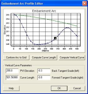
In WMS, man-made embankments are represented as embankment arcs. These embankment arcs are placed along the centerline of the actual embankment. Often these embankment arcs represent roads that cross a drainage. The embankment arc can intersect a stream arc and an in-stream hydraulic structure (a culvert) placed at the intersection to allow water to pass through. For the embankment arc to function correctly in GSSHA, the elevations along the top of the arc must be defined. This is done through the Embankment Arc Profile Editor.
In the Embankment Arc Profile Editor the arc elevations are generated by entering the parameters for a vertical curve. WMS will then take the given parameters and compute the correct elevation values for each vertex of the arc. The parameters needed for the vertical curve are the elevation of the point of vertical intercept, the left (back) tangent slope, the right (forward) tangent slope, and the curve length. Note that the arc need not be a straight line in plan view for the vertical curve to be computed. Below is an example of an embankment arc profile set by creating a vertical curve.
The Embankment Arc Profile Editor is accessible from the feature arc attributes dialog in the GSSHA coverage. The feature arc type must be set to Embankment Arc before the Edit Embankment Profile button will be undimmed.
Related Topics
GSSHA Wiki Main Page
Primer Main Page
- Embankments
- Embankment arcs in WMS
- Embankment arcs in GSSHA
- Summary
