Tutorials:15 Overland Flow Boundary Conditions
From Gsshawiki
This tutorial is compatible with:
- WMS Version 8.2 and later
- GSSHA Version 5.0 and later
Disclaimer: GSSHA tutorial exercises do not necessarily represent real world conditions
Overview
A report can be downloaded here that describes a model used to simulate the water depths on Galveston Island from Hurricane Ike. The results from this model were compared to the measured water depths during the hurricane.
The raw data used for this tutorial can be downloaded here.
Overland Flow Tutorial and Steps
- Open the hydrologic modeling wizard, use the UTM Zone 15 (metric) coordinate system, and define the model boundary.
- Open the DEM (36991726.hdr), the land use data (Houston.shp), and the image (galveston2m.tstopo.web.jpg) (optional).
- Run Topaz to compute the flow direction and flow accumulation grids.
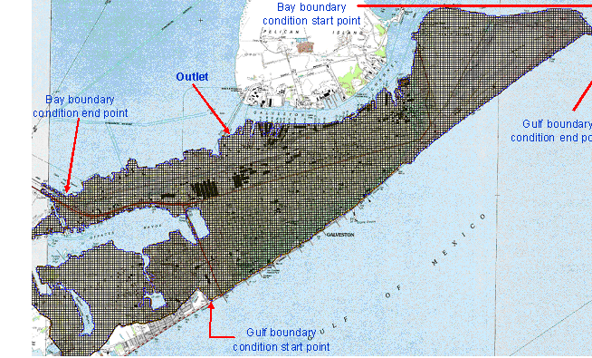
- Delineate the watershed with the outlet located between Galveston Sewage Disposal Plant and Pier 41 in the west shore of the island as shown in the image. Use a stream threshold value of 0.05 square miles. The preliminary watershed area should be approximately 1.21 square miles.
- Starting from the outlet point, create an arc that follows the DEM contour lines to extend boundary of watershed. Once you have outlined your new watershed extent, define your basin, and then convert from basin to polygon. The new watershed area should be approximately 13.07 square miles.
- Select GSSHA as your model and initialize the model data.
- You do not need to set stream arc attributes as you will not use the stream in your model.
- Create a 2D grid with a resolution of 60 m.
- Run a 2-day simulation, starting at 6 PM on 9/12/2008 and ending at 6 PM on 9/14/2008.
- Define your land use coverage by selecting the Create Coverages button in the Define Land Use and Soil Data step of the wizard.
- Create land use index maps. Use the land use index map for your roughness values.
- Read the gssha.cmt file to get initial values for overland Manning’s roughness. In your job control, turn off the Green and Ampt method of infiltration, select no routing, and set your output to write a hydrograph value every 10 minutes and to write in English units. Turn on Channel depth and Channel flow in the Link/Node data set output.
- Set the precipitation method to Uniform and enter an intensity of 10.5 mm/hr for 24 hours.
- Create a node in the start point and end point of your east boundary arc as shown in the image. Set your arc attributes to variable depth and enter the Galveston Pleasure Pier storm surge time series. GSSHA automatically named the time series as ts_26.
- Create a node in the start point and end point of your west boundary arc as shown in the image. Include a node in the middle where the watershed outlet is located. Set your arc attributes to variable depth and enter the Galveston Pier 21 storm surge time series. GSSHA automatically named the time series as ts_27.
- Using the topo map as a guide, create an embankment arc where the levee surrounding Old Fort San Jacinto is located (north of Galveston Island). In the embankment dialog box, set embankment height to 6 m.
- Using the topo map as a guide, create an embankment arc where the seawall goes inland (behind Stewart Beach Park in the northeast section of the island). In the embankment dialog box, set embankment height to 6 m. Make sure that the two embankments don’t overlap.
- Save your model.
- Select the option to clean up your model and make sure there are no errors in your model.
- Run the GSSHA simulation (using GSSHA 5.0). Calibrate your inundation depths to the observed depths using the values shown in this report or using some other calibration method.
- Create an animation filmloop using this model and open the KMZ animation file in Google Earth.
GSSHA Tutorials
GSSHA Tutorial Download Website
