Routing:Defining stream networks with feature objects
Feature polygons, feature arcs, and feature nodes are used in WMS to create the stream network. These feature objects may be created in WMS or imported from another program. Stream channels are defined by feature arcs, lakes by feature polygons, and detention basins and structures by feature nodes.
Stream Channels
Stream channels are defined in WMS by creating or importing stream feature arcs. These feature arcs have attributes that describe the various hydraulic factors of the channels. Stream feature arcs can be defined using any combination of the tools and import options available in WMS, but typically they will be defined from the results of the stream runoff characteristics computed by TOPAZ and generated during the initial delineation of the watershed from the digital elevations. When using the arcs computed by TOPAZ, make sure that the stream network created does not violate the following rules:
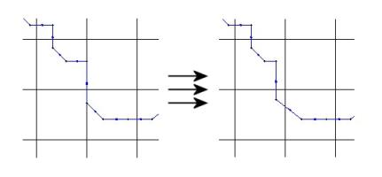
- Stream arcs cannot pass along the edges of cells. They must be moved to one side or the other. Otherwise, WMS is likely to incorrectly define the cells that underlie the channel.
- Stream arcs should not exit the active grid except at the outlet. The arc that exits the grid to form the outlet should terminate shortly after exiting the grid. It is permissible to have the outlet just inside the grid, up to one-half grid cell.
Often, shape files showing the stream location are available. These can be imported into WMS and converted to feature objects or displayed in the background and used as a template for manually constructing the stream arcs. When manually creating stream arcs, all feature lines should be constructed from downstream to upstream.
Lakes
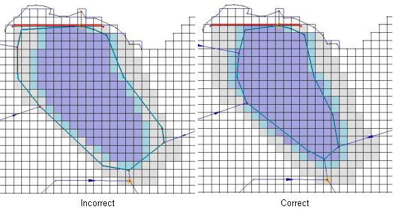
Lakes are represented in WMS as polygons. Lake polygons can either be imported from GIS files or created manually in WMS. Lake polygons serve as reference features and are not actually used by GSSHA. In GSSHA lakes are sets of cells that have been ordered from lowest elevation to highest elevation. This elevation ordering allows GSSHA to fill and drain the lake as it would naturally occur. As the lake is allowed to shrink to, but not below, the minimum water surface elevation, care needs to be taken that channel links entering the lake polygon extend to the minimum water surface elevation cells. The minimum, initial, and maximum water surface elevation cells can be displayed by turning on the appropriate options in the 2D grid display options dialog. The following figure shows how the channels need to extend to the minimum water surface elevation.

Another important aspect of modeling lakes is their delineation. Lakes in GSSHA are represented as a set of cells, ordered by elevation, which describe how the lake should fill and drain. The extents of the lake cells are determined by the interplay of four variables:
- the minimum, initial, and maximum water surface elevations
- natural topography and bathymetry
- the location of the lake outlet
- the location of embankment arcs.
The minimum and maximum water surface elevations control the growth and shrinkage of the lake while the initial water surface elevation controls the initial lake level. These values are set in the polygon attributes dialog. Good topography and bathymetry are very important for the cells between the minimum and maximum water surface elevations. The location of the outlet and the embankment arcs is critical to the successful delineation of the lake. All lakes must have both an outlet structure and embankment arcs restricting the growth of the lake. The only exception to this rule is for a lake that is only restricted by the grid boundaries because the lake outlet is also the simulation outlet.
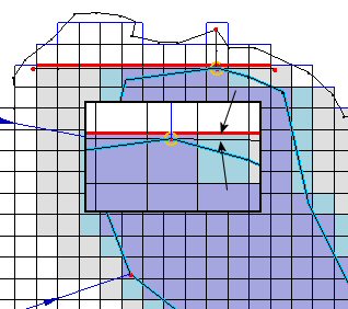
Outlet and embankment arc placement is critical for successful lake delineation. The lake delineation is done automatically by WMS but controlled by the placement of the lake outlet and associated embankment arcs. Embankment arcs are not mapped directly to GSSHA as input but are interpolated to cell boundaries where they become embankment edges and impede flow from one cell to another. In placing the lake outlet and embankment arcs, care should be taken to make sure that the outlet is upstream of the embankment edge, even though the arc should be attached to the lake outlet. The delineation routine for the lakes begins at the cell containing the lake outlet and searches nearby cells, adding them to the lake cell list, until it runs into a) a cell above the maximum water surface elevation, b) the grid boundary, or c) an embankment edge. If the embankment arcs are incorrectly defined (e.g. do not reach cells above the maximum water surface) it is quite possible for the lake delineation routine to continue downstream and incorrectly engulf major portions of the simulation. This is not to say that flow cannot overtop the embankments, only that embankment arcs should be placed so as to correctly allow the lake to be delineated. Embankment arcs are covered in-depth in the next chapter, including how to define low spot locations where water may overtop the embankment. The following diagram shows an example of the correct placement of embankment arcs and the lake outlet.

Structures and Detention Basins
Hydraulic structures and detention basins are represented in WMS as feature points. Several hydraulic structures may be defined at a single location. For example, a double box culvert where a road intersects a small stream may be represented as two square culverts and a broad-crested weir representing the road in case of overtopping. Detention basins are treated as lakes and must also have an outlet structure at the same feature point that represents the detention basin. The above rules about embankment arcs and lake outlets also apply to detention basins.
Related Topics
GSSHA Wiki Main Page
Primer Main Page
- Routing
- Links and nodes
- Defining stream networks with feature objects
- Link types
- Node spacing
- Smoothing the profile
- Troubleshooting channel routing problems
- Tips on creating lakes
