Surface Water Routing:Overland Routing with BMPs
GSSHA has the ability to simulate sub-grid scale best management practice features. These are considered point features that alter the hydrology of the cell they are in.
Contents
[hide]5.9.1 Simulating BMPs in GSSHA
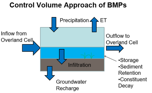
Point models of small scale features are simulated in GSSHA as part of a sub-grid BMP Calculator. They are included as a point solution within a grid cell (or other discrete unit). The Point solution is added to the solution at the grid cell to get the total cell response.
Point models affect the volume and timing of flow, sediment, and constituents. The control volume approach allows a wide range of BMPs to be simulated while using a common approach.
Essentially, the computed overland flow volume without BMPs is routed through the BMP, which then modifies the overland flow. The result is returned to the cell. A cell can have multiple BMPs. The outflow from one BMP is routed to the next in series.
5.9.2 Including BMPs in a GSSHA Project
To include BMPs in a project, 1) include the OV_BMP card in the project file and 2) include the BMP table in the mapping table file.
5.9.2.1 BMP Mapping Table
The BMP mapping table is "BMPS".
It has the number of ID NUM_IDS, followed by the number of contaminants, NUM_CON, which should be used if you are simulating contaminants, and if so the same number, and in the same order.
The table has 10 input parameters plus one parameter for each NUM_CON:
1) Type – Type of BMP, integer
 0-no bmp
 1 or greater BMP in the cell
2) Inflow Type – integer 0 to 4
 1 – fraction of water in the cell
 2 – specified discharge
 3 – weir flow
 4 – overland flow
3) Outflow Type – integer 0 to 4
 1 – fraction of water in the cell
 2 – specified discharge
 3 – weir flow
 4 – overland flow
4) Area (m2)
5) Retention depth(mm)
6) Saturated hydraulic conductivity of the bed (cm/hr)
7) Inflow_variable - dependent on Inflow Type
 Inflow Type 1 – fraction of water in the cell (0-1)
 Inflow Type 2 – specified flow (cms)
 Inflow Type 3 – weir length (m)
 Inflow Type 4 – Manning roughness coefficient
8) Outflow variable – same as inflow
9) Soil Depth (cm)
10) TSS treatment efficiency (%)
11+) If NUM_CON > 0 Contaminant treatment efficiency (%) for each contaminant
GSSHA User's Manual
- 5 Surface Water Routing
- 5.1 Channel Routing
- 5.2 Overland Flow Routing
- 5.3 Channel Boundary Conditions
- 5.4 Overland Boundary Conditions
- 5.5 Embankments
- 5.6 Overland/Channel Interaction
- 5.7 Introducing Discharge/Constituent Hydrographs
- 5.8 Overland Routing with Snow
- 5.9 Overland Routing with BMPs

